An article in the Buenos Aires Herald sparked my interest in writing this post. I have touched upon the effect deforestation has had on flooding, very briefly, in my previous blog post and I have decided to dedicate an entire post to quite a topical area of interest. The floods that have struck South America (Argentina, Paraguay and Brazil) occurred as a result of heavy rain brought on by an El Nino event. Interestingly, the countries that were most effected by this rainfall were the countries that had experienced the greatest amount of deforestation in recent years due to increased demand for Soya.
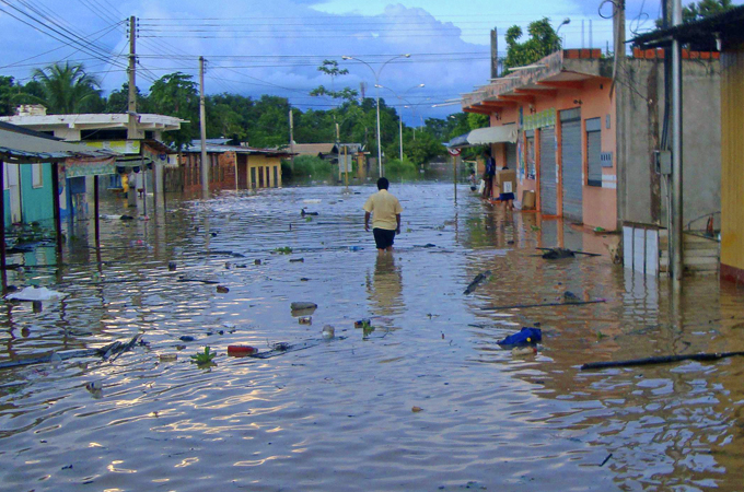 |
| Citizens in Cobija (Bolivia) wade through flood waters that have destroyed their homes (Al Jazeera) |
The relationship between trees and flood events is one that appears to be very simple in that trees reduce the impact of flood events but in reality it is much more complicated. In simple terms trees reduce runoff to a river in several ways:
- Intercept rainwater by capturing it in leaves
- Evaporation/transpiration
- Leaves reduce raindrop impact meaning there is less soil erosion.
- Tree roots absorb water droplets from the soil.
- Tree roots hold the soil together reducing sediment movement and preventing landslides.
With floods the most common natural disaster in tropical areas, most of the academic research has been focused on South East Asia and the Amazon. Tan-Soo et al. (2014) who explored flooding in Malaysia came to the same conclusion as the article in the Buenos Aires Herald. They concluded that the conversion of tropical forests to oil palm plantations increased the number of days flooding occurred, but only during the wettest months of the year. A similar study found the same to be occurring in Amazonian Peru where the height of annual flood waters had increased over the last decade in correlation with deforestation (Gentry and Lopez-Parodi 1980). However, there has been criticisms of this study (Nordin et al. 1982) because it drew conclusions that were not supported in the evidence/data. It assumed river stage correlated directly with river discharge which as Nordin et al. stated was not always the case. Furthermore, Gentry and Lopez-Parodi dismissed an increase in flood heights due to precipitation despite analyzing the years with unusually high precipitation.
Clark (1987) is critical of research studies into land use change (mainly that of converting deforestation into farmland) suggesting that these studies are limited because they only ever focus on 1 or 2 catchments and that this is not representative of all catchments. This is indeed true, the two studies discussed already only focused on 1 catchment in a tropical region. Clark does make an interesting point that the knowledge that trees can reduce flooding has been around for centuries - in 14th century Italy it was suggested that afforestation in upland areas could combat flooding - so why are we continually clearing forests and making the same mistakes?
Lets throw in some statistics - a 10% decrease in forest cover increased flood frequency between 4-28% and increased flood duration by 4-8% (Bradshaw et al. 2007).
It is widely agreed that on a local scale trees mitigate medium scale flood events but on a large scale flood event this is not the case (Tan-Soo et al. 2014; The Economist 2005). The Economist offers a very different take on flooding compared to the previous articles and blames economics as the cause of flooding rather than widespread forest clearing in South East Asia. Towns and cities are situated on hazardous areas such as flood plains because of the significant economic benefits of situated near a river or the coast - transportation, trade, sanitation, food source, employment etc. Despite looking at the cause of flooding in economic terms, the article says measuring flooding in economic loss rather than geographical extent of the water gives the impression that the floods are more severe than they actually are.
It is a really interesting article and a great read - it can he found here
 |
| Deforestation on a floodplain (source) |
Flooding within a river basin is influenced by other factors such as hydrology, as well as deforestation, but the focus of this post has been to explore flooding as a result of deforestation. It is a controversial topic with which different people have different opinions. It has further helped understand the overarching question of this blog - is deforestation a necessary evil? - by exploring some very negative impacts of deforestation. Flooding demonstrates how deforestation erodes human life and the economies of developing nations and illustrates the need for greater forest protection policies in areas that are already prone to flooding.
